Three students from SMU School of Information Systems have developed an app that helps bring together the residents of Yuhua community in Jurong through various events.
Called Meetupleh.com, the app, developed by Mr Andre Ng, Mr Lam Kee Wei, and Ms Heng U San, enables users to propose events which will be executed when sufficient number of members of the community pledge to participate.
In addition to self-proposed events, users are able to conveniently locate events happening around them and search for potential venues to hold future events by integrating Google Maps base layers with OneMap data.
Since events are organised on Meetupleh.com, it allows the Yuhua Community leaders to analyse the data collected by simply asking a question like “Are there more male participants for sporting events?” The question is then interpreted by the application and the appropriate result is selected and displayed.
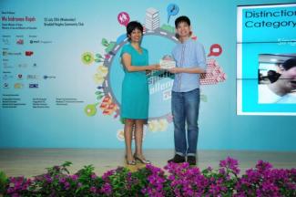
The app helped the team pip teams from other universities, polytechnics, Institute of Technical Education, and junior colleges in Singapore to win the Distinction Award at the Singapore Geospatial Challenge (SGC) 2014.
The teams were judged on the impact, innovation and presentation of their submissions.
Organised by the Singapore Land Authority, the competition, first held in 2013, aims to encourage the use of Geographic Information Science & Technology in schools.
For SGC 2014, communities in Singapore issued "Community Challenges" to the participants. Through the SGC, participants will connect with and better understand the community, create geospatial applications and analysis that are directly beneficial to and customised for the community, and celebrate the new bonds made and new knowledge gained.
Said Andre, “We chose to work with the Yuhua Community because I was familiar with the challenges they faced with organising events and the team saw this as a unique opportunity to apply our knowledge from multiple IS disciplines to solve them.”
“While we had technical knowledge to get the application up and running, it was a new experience to work with the Community Leaders to understand their core concerns and deliver a solution that caters to their real needs,” added U San.
Before starting work on the app, the team met with Yuhua’s community leaders in May to better understand the project in detail.
What is Geospatial?
How do people move from place to place? What routes do they take? How do diseases spread? Do the amenities and services near this community serve them adequately? Where should new facilities be placed to be most effective? These are some of the questions where Geospatial Information Science & Technology (GIST) can offer some insights.
Geospatial is about describing things and phenomenon associated with location, distance, mobility, spaces and places. Geospatial professionals take geospatial data and generate new insights based on this data.
GIST has become increasingly important in formulating public policy and delivering public services. Key contributors to this trend include (i) the exponential increase in geospatial data due to the increase in use of mobile devices, GPS and the Internet of Things; (ii) more advanced analytic techniques that leverage on geospatial data; and (iii) the realisation that geospatial knowledge is critical to improving cities in many ways, such as for building smart sustainable cities, for improving transport/energy infrastructure and for building communities.
[Source: Singapore Geospatial Challenge]
[Photo: Andre Ng represented the SMU winning team to receive the award from Guest-of-Honour, Senior Minister of State for Law and Education Ms Indranee Rajah, at the Awards Ceremony on 23 July 2014.] Photo: Singapore Land Authority